
Comments on Chehalis Basin Aquatic Species Restoration Plan
Conservation Northwest / Jan 15, 2020 / Cascades to Olympics, Habitat Restoration
We submitted comments on the Aquatic Species Restoration Plan in the Chehalis Basin, proposing greater considerations for habitat connectivity and stronger strategies for community engagement.
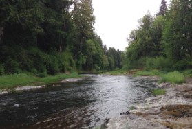
The Chehalis Basin Strategy is a plan to restore habitat and reduce flood damage on the second largest river basin in Washington state. Once home to strong runs of wild salmon and a highly-productive ecosystem, habitat degradation from development and land-use change has prompted the state to draft a Chehalis Basin Aquatic Species Restoration Plan (ASRP) to restore habitat while also maintaining thriving rural communities.
Our new Cascades to Olympics program dovetails off Chehalis watershed improvements and other efforts to cost-effectively provide means for fishers, wolves, Roosevelt elk and other wildlife to cross I-5 and Highway 12. As a part of this program, we submitted comments on the ASRP Phase 1 Draft Plan. We also previously submitted scoping comments on the Chehalis River Basin Flood Damage Reduction Project and the Chehalis Basin Strategy.
In summary, we would like to see more consideration for habitat connectivity in the basin, as improving and restoring corridors for aquatic and terrestrial species is an essential part of increasing ecosystem resiliency to climate change. We also proposed a larger focus on basin-scale forest and land management based on projected climate change impacts on river temperatures and wildlife populations, and strategies for stronger engagement with local communities.
January 14th, 2020 – Electronic Copy (PDF)
Aquatic Species Restoration Plan Phase 1 Draft Public Comment
To: The Chehalis Basin ASRP Steering Committee
Conservation Northwest would like to express our appreciation for the opportunity to offer comments on the phase 1 draft of the Aquatic Species Restoration Plan (ASRP). Our comments support the general scope and objectives of the ASRP scenarios, and we also seek to highlight areas in the ASRP that can be strengthened and refined to increase landscape functionality for target aquatic and semiaquatic species. In addition, we make comments/recommendations on building resilience to climate change in the Chehalis Basin for target and nontarget species. Lastly, we utilize the prompts suggested on the Chehalis Basin Strategy website to direct comments, suggestions, and recommendations.
1. What do you value about each of the three restoration and protection scenarios described in the ASRP and what would you change? Are there other actions and/or areas needed to make the basin more resilient to climate change?
Values of the proposed restoration/protection scenarios
- The proposed extent of each scenario and the resulting hundreds of miles of riparian corridor restoration and protection.
- The focus on target species’ habitat.
- The potential gains of scenario 1 and scenario 3.
- Inclusion of semiaquatic species.
- Focus on climate change and ecological resilience.
- Focus on partnerships, collaboration, and stakeholders.
Supported changes/inclusions
- Scenario 1 only increases salmonid populations in the short-term, while in the long-term a scenario 1 only approach would result in decreases in all target salmonid populations. Furthermore, scenario 2 shows minimal gains in population recovery. Therefore, we recommend that all three scenarios are implemented, resulting in coho, spring Chinook, and steelhead populations experiencing net growth overtime. Furthermore, we think that that a scenario 4 should be considered that allows for chum and fall Chinook populations to also grow or stabilize.
- Include data and maps from ongoing mapping efforts being conducted in the Chehalis Basin by the Cascades to Coast Landscape Collaborative, Conservation Biology Institute, and the Washington Wildlife Habitat Connectivity Working Group. These maps can locate areas on roadways which have wildlife habitat connectivity conflicts with transportation corridors and where potential habitat and linkages exist within the Chehalis Basin, and where general connectivity corridors exist within the landscape based on current vegetation and movement barrier patterns. Furthermore, the “naturalness” maps can highlight landscape level connectedness between natural and protected areas, which can be used to locate areas where general landscape connectivity overlap with ASRP project areas. Furthermore, these maps will identify habitat and linkages for 5 focal species including beaver, which is an ASRP target species, when they are completed in Fall 2020.
- Include wildlife-vehicle collisions and road mortality data for target semiaquatic species within the Basin, particularly on high volume state highways like I-5, 12, 101, and 8. Propose solutions to collisions with target semiaquatic species at key locations and give preference to projects focused on locations that have the potential to protect both aquatic/semiaquatic target and terrestrial nontarget species. Because large open structures on high volume interstates without wildlife fencing may show higher rates of collisions and act like a trap for some species such as beaver, it is important to protect existing crossing structures with appropriate wildlife infrastructure, like fencing and other appropriate equipment needed to keep wildlife off highways.
- Investigate riparian corridor pinch points where target rivers run under state highways at key locations like the Newaukum and Skookumchuck Rivers on I-5 and the Satsop and Wynoochee Rivers on Hwy 12. Consider projects which focus on restoration, structure enhancement, limiting human usage, wildlife infrastructure (fencing), and adaptation of of any planned fish passage projects to allow passage of all aquatic/semiaquatic target species and terrestrial nontarget native species.
- Develop a clear and explicit timeframe for the project. Currently the ASRP assumes a very quick implementation process, or it at least appears to. How will models and data be reanalyzed to be current if projects are 30 years away? What would the overall time frame look like if the plan was implemented in 10 years? How fast do the objectives of the overall ASRP have to be to meet the target recovery goals and potential benefit goals for salmonids by mid to late century, as laid out in the ASRP?
- The ASRP should consider incorporating insights from social sciences, including human dimensions of wildlife conflict and conservation conflict transformation when working with private landowners given that gaining voluntary participation is such an important element of successful implementation of the restorations goals of the plan.
Climate Change Resilience

Improving native flora and fauna’s ability to naturally adapt to climate change through migration and dispersal, requires providing connected riparian corridors at a landscape level. In addition, the corridors in the Basin functionally connect high altitude climate refugia, to lowland water systems, making them key routes for many species adapting to a changing climate. Therefore, if regional scale climate resilience is to be achieved, providing contiguous restored and protected riparian habitat from the coastal estuaries to the Cascades and Olympics for all native species should be a goal of the ASRP. The following suggestions would benefit all target species as well as other species and processes not specifically targeted in the ASRP.
- Invest in studies that locate climate refugia in headwaters. Limit forestry and development in identified areas.
- Basin wide water temperatures are predicted to increase to unhabitable levels for most salmonid populations. What actions will be taken to ensure enough canopy cover is erected quick enough to prevent and minimize the impact this could have on the ecosystem? There is emerging research suggesting that forest management at a watershed scale affects seasonal low flows and therefore temperature. This research should be taken into account and potentially conducted in the Chehalis Basin in order to plan additional restoration activities in forested portions of the watershed so downstream work on riparian restoration is not wasted. The ASRP should consider how basin wide temperature reduction will be accomplished if forestry and agriculture are not adapted in headwaters and tributaries to reduce temperature and adapt to climate change impacts. In addition, it will be important to consider what mechanisms can be put in to place to ensure temperature stabilization if voluntary landowner actions are not sufficient.
- Locate main pinch points on state highways that have existing structures that could be enhanced or rebuilt to facilitate movement of all target and nontarget species. Offer options to enhance those that are large and already passable, and redesign/replace those that block ecological connectedness. Focus on three or four key corridors that create a broad network through the Basin, like the Newaukum River structure and corridor, and the Satsop and Wynoochee corridors.
- Explore acquiring lands around large culverts, underpasses, structures on/around major state highways to maintain naturalness, limit human usage, and limit development.
- Consider nonnative plants that may have greater resilience to climate change.
- Make considerations for previously extirpated species that may return to the Chehalis Basin. Also, make considerations for species not historically found in the Chehalis Basin, as pressures from climate change may force them to populate the region.
2. The success of the ASRP relies on landowner support for increased restoration and protection. What additional actions/support is necessary to ensure landowners are supportive and helping to lead implementation through their involvement in this effort?
Overall, Conservation Northwest supports the ASRP and the great strides taken to engage the community and landowners within the Chehalis Basin. However, there may be room to improve and expand landowner participation.
- Consider using approaches from Conservation Conflict Transformation, which focus on identifying underlying and deep-seated identity conflicts that hinder large-scale projects such as the ASRP, to engage residents of the Basin who will be affected by, or whose participation will be needed for success.
- Hold workshops and create working groups of landowners, beneficiaries, non-profits, and ASRP officials aimed at cataloging comments/concerns and listening to and engaging with landowners on an ongoing basis.
- Bring workshops to the smaller communities, engage people where they live.
- Include community outreach that includes all members of the community, not just landowners with property along a riparian corridor.
- Engage with groups like the Cascades to Coast Landscape Collaborative (CCLC), who have held workshops consisting of landowners, working lands officials, agencies, and conservation groups in the Chehalis Basin. One of the goals of the CTOCLC is to produce GIS based maps that highlight where working landowner needs, ecosystem service needs, social network needs, and conservation needs spatially overlap. These maps can help to highlight and locate areas where landowner needs already coincide with conservation needs.
- Develop a holistic outreach program that targets as many avenues for public engagement within the Chehalis Basin as possible. Thinking broadly about how to make sure landowners and the public are educated and included will improve overall buy-in from the community and landowners. Some ideas might include K-12 education, community center workshops, and more landowner participation through the facilitation of conservation districts.
3. The level of restoration needed in a relatively short timeframe is unprecedented. What will improve the certainty that the work can get done at the scale proposed, and in the timeframe needed to counter the negative effects of climate change?
- In order to achieve such a high level of restoration in such a short time frame, including as many groups and agencies in the process as possible may help. Also, improving how outside groups can access and utilize ASRP information and funding mechanisms may result in projects being accomplished more quickly than they would without broader collaboration.
- Prioritize connecting contiguous riparian corridors that connect the lowlands of the Basin to the Olympics and Cascades, creating corridors for wildlife dispersal and migration. Also, prioritizing restoration in areas that connect large swaths of climate refugia and areas that provide landscape connectivity can potentially increase species’ natural adaptive opportunities.
4. For practitioners and those interested in doing restoration in the Chehalis Basin – How does the Phase 1 ASRP help you as a practitioner? Where do you see your role in implementing this plan? What specifically would you like added in future phases that would help you implement the actions needed to protect and restore aquatic habitat in the Chehalis Basin?
- Phase 1 helps to identify areas in the Basin with the greatest need for action and it helps guide project development.
- Developing a practitioner’s handbook that details explicit funding requirements, mechanisms, priorities, and opportunities could help to streamline the practitioner/project process.
- Help partners increase institutional capacity by streamlining access to resources.
Thank you for providing the opportunity to provide input on the ASRP Phase I draft. We look forward to continuing to support the ASRP efforts and whatever changes and/or considerations are made to address the concerns laid out in this letter.
Sincerely,
Paula Swedeen, Ph.D.
Policy Director
Brian Stewart,
Project Manager, Cascades to Olympics Program
Conservation Northwest
LEARN MORE ABOUT the chehalis basin in THIS VIDEO, and stay tuned for more information ABOUT our cascades to olympics program!
